 Koch Bihar (কোচবিহার জেলা, Rajbongshi/Kamatapuri : কোচবিহার, old name was: Cooch Behar) (1586—1949), now in West Bengal, India, was a small kingdom located south of the Himalayan kingdom of Bhutan. It was formed when the Kamata Kingdom under the Koch dynasty split following the death of Nara Narayan in 1586. The eastern portion, Koch Hajo, was soon absorbed by Ahom. The western portion, Koch Bihar, although nominally independent became a vassal state in turn of the Mughal Empire, of Bhutan, the British East India Company, and of the British Raj. It acceded to and merged with India in 1949 and became a part of West Bengal. The district, Cooch Behar District, is named after this erstwhile kingdom.
Etymology: The name “Cooch-Behar” is derived from the name of the Koch Rajbongshi tribe that is indigenous to this area. The word “Behar” is the Sanskrit word “Bihar” (to travel) which means the land through which the “Koch Rajbongshi” Kings used to travel or roam about (“Bihar”). Present name is: Koch Bihar.
The greatest Koch Rajbongshi King that has ever ruled in the Kingdom of Kamatapur is Maharaj Naranarayan, as well as his younger brother Prince Chilaray and other descendents. Historic Kamatapur comprises the total North Bengal maximum parts of Assam, some parts of present Bangladesh, Kishanganj district of Bihar and a few parts of Bhutan. The Koch-Rajbongshi community is demanding a separate state of their own comprising the parts of their old Kingdom to save their centuries-old culture from extinction.
History: The Koch dynasty originated from Mahishya community and has ruled the area around the town of Koch Bihar since the 16th century. The state remained unaffected by the great changes that overtook its surrounding provinces in the decade following the Battle of Plassey in 1757. However, it was invaded by Bhutan in the latter half of the 18th century, which prompted a British Ambassador to Bhutan, George Bogle to enter into a formal treaty alliance with the British in 1775. In 1947, the state acceded to the dominion of India and merged with the Union of India shortly afterwards.
Over time, Koch Bihar has been transformed from a kingdom to a state and from a state to the present status of a district. Before 28 August 1949, Koch Bihar was a Princely State ruled by the maharaja of Koch Bihar, who had been a feudatory ruler under the British Government. By an agreement dated 28 August 1949, Maharaja Jagaddipendra Narayan of Koch Bihar ceded full and extensive authority, jurisdiction and power of the state to the Dominion Government of India. The transfer of administration of the state to the Government of India came into force on 12 September 1949. Eventually, Koch Bihar was transferred and merged with the province of West Bengal on 19 January 1950 and from that date Koch Bihar emerged as a new District in the administrative map of West Bengal.
Geography: Koch Bihar is a district under the Jalpaiguri Division of the state of West Bengal. Koch Bihar is located in the northeastern part of the state and bounded by the district of Jalpaiguri in the north, state of Assam in the east and by Bangladesh in the west as well as in the south. The district forms part of the Himalayan Terai of West Bengal.
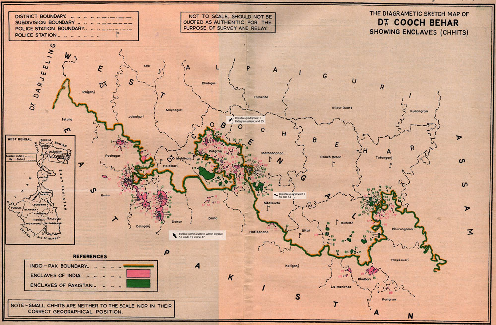
A geopolitical curiosity is that there are 92 Bangladeshi exclaves, with a total area of 47.7 km² in Cooch-Behar. Similarly, there are 106 Indian exclaves inside Bangladesh, with a total area of 69.5 km². These were part of the high stake card or chess games centuries ago between two regional kings, the Raja of Koch Bihar and the Maharaja of Rangpur.
Twenty-one of the Bangladeshi exclaves are within Indian exclaves, and three of the Indian exclaves are within Bangladeshi exclaves. The largest Indian exclave, Balapara Khagrabari, surrounds a Bangladeshi exclave, Upanchowki Bhajni, which itself surrounds an Indian exclave called Dahala Khagrabari, of less than one hectare. See also Indo-Bangladesh enclaves.
Soil: Being the district near the Eastern Himalayan foothills, after rains in the catchment area of each of the rivers generally attain strong current and flood the adjacent area. The turbulent water carries sand, silt, pebbles which causes many problems in productivity as well as hydrology. The soil is formed by alluvial deposits and is acidic in nature. It is friable loam to sandy loam ranging in depth from 0.15 to 1-metre. The soil has a low level of nitrogen while potassium and phosphorus levels are medium. Deficiency of zinc, calcium, magnesium and sulphur is quite high.
Rivers and topography: Koch Bihar is a flat country with a slight southeastern slope along which the main rivers of the district flow. Most of the highland areas are in the Sitalkuchi region and most of the low-lying lands lie in Dinhata region.
The rivers in the district of Koch Bihar generally flow from northwest to southeast. Six rivers that cut through the district are the Teesta, Jaldhaka, Torsha, Kaljani, Raidak, Gadadhar and Ghargharia.
Climate: The district of Koch Bihar has a moderate type of climate characterised by heavy rainfall during the monsoon and slight rainfall in the month of October to mid-November. The district does not have high temperatures at any time of the year. The summer season is from April to May with April being the hottest month with mean daily maximum of 32.5 °C and mean daily minimum of 20.2 °C. The winter season lasts from late November to February, with January being the coldest month with temperature ranging from 10.4 °C to 24.1 °C. The recorded temperature minimum is 3.9 °C and respective recorded maximum is 39.9 °C. The atmosphere is highly humid throughout the year, except the period from February to May, when the relative humidity is as low as 50 to 70%. The rainy season lasts from June to September. The district’s average annual rainfall is 3201mm.
